Machine Learning in ArcGIS : Map Land Use Land Cover in GIS

Why take this course?
🌏 Master Machine Learning in GIS: Map Land Use & Land Cover with ArcGIS 📡
Course Overview:
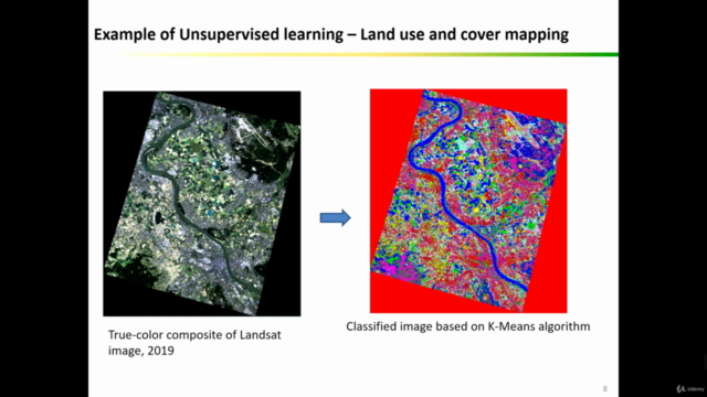
Embark on a journey to master the fusion of Machine Learning and Geographic Information Systems (GIS) through the lens of Remote Sensing. This course is your gateway to advanced geospatial analysis using ArcGIS, where you'll learn how to map Land Use & Land Cover (LULC) with precision and flair. 🌍
Course Highlights:
🚀 What You'll Get:
- Practical LULC Mapping Skills: Learn the ropes of advanced mapping techniques.
- ArcGIS Mastery: Gain proficiency in handling geospatial data analysis.
- Satellite Imagery Analysis: Dive into satellite-based image analysis for Remote Sensing applications.
- Machine Learning Application: Understand how to apply Machine Learning algorithms for accurate LULC mapping.
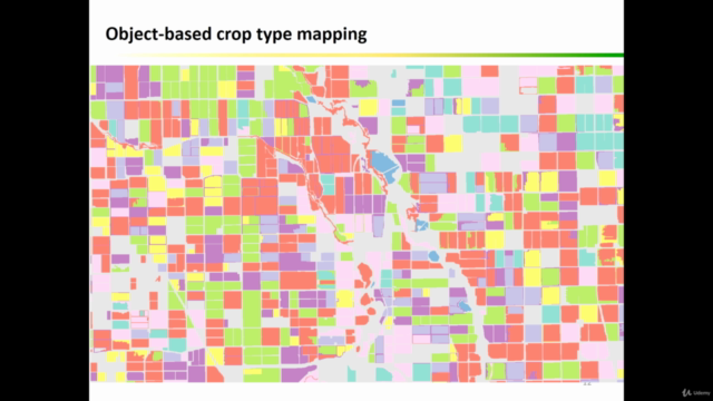
- Object-Based Image Analysis Techniques: Explore sophisticated segmentation methods.
- Change Maps & Accuracy Assessments: Learn to create maps that track changes in land use and conduct thorough accuracy assessments.
- Comprehensive Resources: Access downloadable datasets, Java code files, and step-by-step instructions.
Course Focus:
🎓 For the Aspiring Geospatial Analyst: This course is tailored for those with a grasp of ArcGIS who aspire to elevate their skills to the next level. Whether you're a student, professional, or hobbyist, you'll emerge confident in applying Machine Learning algorithms to LULC mapping and object-based image analysis with real-world datasets in ArcGIS.
Why Choose This Course?
🌟 Stand Out in the Field: This course is your key differentiator. It's not just about understanding complex concepts; it's about applying them to real-world scenarios. You'll come out of this course with practical skills that set you apart from others, making you a valuable asset in any geospatial project.
What You'll Learn:
- Advanced ArcGIS Skills: Hone your expertise in geospatial analysis within ArcGIS.
- Machine Learning & GIS Integration: Grasp the concepts of Machine Learning and how they apply to GIS.
- Satellite & UAV Image Classification: Learn to classify images using various Machine Learning algorithms.
- Data Collection & Management: Master training and validation data collection, essential for accurate analysis.
- Object-Based Analysis Techniques: Implement powerful object-based image analysis and segmentation methods.
- Change Maps Creation: Visualize land use and land cover transformations with change maps.
Enroll Today:
This course is the perfect fit for professionals from various domains such as geographers, programmers, social scientists, geologists, GIS experts, and Remote Sensing enthusiasts who want to create detailed LULC maps or conduct land use change detection studies.
Included in the Course:
- Access to All Data & Resources: You'll receive datasets and Java code files used throughout the course to ensure you have everything you need to follow along and apply what you learn.
Don't miss this opportunity to transform your skills with ArcGIS and Machine Learning. Enroll in "Machine Learning in ArcGIS: Map Land Use & Land Cover" today and unlock a new dimension of geospatial analysis! 🚀💡
Course Gallery


Loading charts...