Rainfall Threshold for Landslides Prediction with Excel only

Why take this course?
🌧️ Master Rainfall Thresholds for Landslide Prediction with Excel 🚀
Course Title: Using Excel for ID, IE, and Antecedent Thresholds for Early-Warning Systems, Landslides & Geo-Hydrological Risk Analysis
Course Headline:
Dive into the world of geohazard risk analysis with Dr. Omar AlThuwaynee as your guide! This comprehensive course focuses on harnessing the power of Excel to develop and validate precipitation rainfall thresholds that induce landslides, a critical component in early-warning systems for geohazards.
Course Description:
🚀 Elevate Your Analytical Skills 📊
Welcome to a transformative learning journey where you'll master the art of predicting landslides using Excel. In this course, we explore the intricacies of setting up and validating effective precipitation thresholds that trigger landslides. With hands-on exercises and real-world data, you'll gain a deep understanding of the factors that contribute to geohazard events.
📚 What You Will Learn:
-
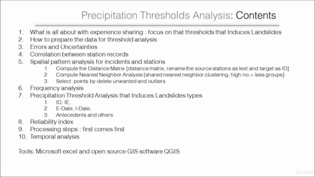
Threshold Analysis Fundamentals: Understand what precipitation thresholds that induce landslides entail and the importance of experience sharing in this domain.
-
Data Preparation Techniques: Learn how to prepare your data for thorough threshold analysis, ensuring you have clean and usable datasets.
-
Managing Errors and Uncertainties: Gain insights into errors and uncertainties that may arise during data analysis and how to address them.
-
Station Record Correlation: Master the art of correlating station records and analyze the spatial patterns associated with landslide incidents and stations.
- Compute the Distance Matrix
- Perform Nearest Neighbor Analysis
- Select points by deleting unwanted and outlier data
-
Deep Dive into Correlation Analysis: Explore correlation analysis to understand the relationship between various factors in landslide events.
-
Precipitation Threshold Analysis: Dive into threshold analysis for Induced Drainage (ID), Induced Excess (IE), and other antecedent conditions, including E-Date and I-Date.
-
Reliability Index Determination: Learn how to assess the reliability of your predictive model using a robust reliability index.
-
Temporal Analysis: Understand the temporal dynamics that influence landslide occurrences.
Tools of the Trade: This course leverages the strengths of Microsoft Excel and open-source GIS software, QGIS, to provide you with a comprehensive toolkit for analysis.
Course Highlights:
✨ Real Data Application: The exercises provided in this course are accompanied by Excel sheets and relevant articles, ensuring you have the practical tools necessary to apply what you learn.
📊 Step-by-Step Tutorial: From data preparation to analysis, follow a structured approach that covers all the processing steps needed for reliable landslide predictions.
Citation and Data Protection:
Please note that the data used in this tutorial is protected under copyright law, specifically related to Landslides (Journal of the International Consortium on Landslides). The article referenced in this course is:
- Althuwaynee O F., Asikoglu O. & Eris E. (2018) "Threshold contour production of rainfall intensity that induces landslides in susceptible regions of northern Turkey", Landslides, DOI: 10.1007/s10346-018-0968-2
Ensure to cite this article when using the data and methodologies from this course.
Join us in this analytical adventure where you'll transform raw data into actionable insights for early landslide warning systems and risk assessment, all within the versatile environment of Excel! 🌄📈🎉
Course Gallery


Loading charts...